
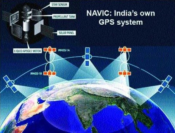
NavIC full form is Navigation with Indian Constellation developed by the Indian Space Research Organisation(ISRO). It is India’s independent and stand-alone navigation satellite System. It is a constellation of 7 satellites that cover the whole Indian landmass and up to 1500 km beyond international boundaries. Originally this mission was approved in 2006 as IRNSS(Indian Regional Navigation Satellite System) by the Indian Government and is expected to be completed in 2011 but unfortunately, it became operational in 2018.
With launch of the 7th satellite IRNSS-1G in 2016 Prime Minster Narendra Modi renamed IRNSS as NavIC. The word NavIC is adapted from the Hindi word “navik” which means ‘sailor’ or ‘navigator’.
It provides two services 1st one is Restricted Services (RS) for defense forces and the other is Standard Position Service (SPS) for civilian uses. For civilians uses position accuracy is less than 15 meters and for defense uses position accuracy is less than 5 meters also SPS signals are compatible with other satellite navigation systems like GPS of the USA, Galileo of the EU, Glonass of Russia, and BeiDou of China.
Budget of NavIC
It was approved at an initial cost of $174 million in 2006 but the average life of a satellite is 10-12 years after that a new satellite will replace the failed one. There are 7 satellites in NavIC, The first satellite IRNSS-1A which launched in 2013 has been replaced with 8th satellite.
A new version of NavIC
Indian Space Research Organisation (ISRO) is still focusing on a series of enhancements to the NavIC and trying to make it equivalent to the Global Positioning System(GPS) of the USA so that more people use it. For this ISRO will replace all satellites with upgraded satellites in the future and make it NavIC 2.0.
Present NavIC works on signals in L5, S-band, and short-code to provide positioning data, However, most mobile and wearable systems on chips(SoCs) support the L1 band signals to overcome this drawback ISRO will launch a new generation of satellites NVS-01 in May 2023 which will replace IRNSS-1G satellite which was launched in 2016. This new satellite has L5, S-band, and L1 frequencies, L1 frequency which are mostly used in Global Positioning Systems (GPS).
Currently, Indian satellite navigation systems provide only short codes to Indian defense forces, in the upgraded version this short code will change into a long code so that the signal can not be spoofed or breached.
Satellite Position of NavIC
NavIC is a constellation of 7 satellites and a network of ground stations. The first three satellites are put in geostationary orbit at 32.5 degrees East, 83 degrees East, and 129.5 degrees East, and the other four satellites of the cancellation are placed in inclined geosynchronous orbit with the equatorial crossing of 55 degrees East and 111.75 degrees East with two satellites in each plane with 29 degrees inclination.
| Sr. no | Satellite | Specification |
| 1 | IRNSS-1A Launch date 1 July , 2013 | Geosynchronous at 55 deg E longitude with 29 deg inclination Mission Life 10 years |
| 2 | IRNSS-1B Lanch date 04 Apr 2014 | Geosynchronous at 55 deg E longitude with 29 deg inclination Mission Life 10 years |
| 3 | IRNSS-1C Launch date 16 Oct 2014 | Geostationary at 83 deg E longitude Mission Life 10 years |
| 4 | IRNSS-1D Launch date 28 March 2015 | Orbit Type- Geosynchronous Orbit Mission Life- 10 years |
| 5 | IRNSS-1E Launch date 20 January 2016 | Orbit Type- Geosynchronous Orbit |
| 6 | IRNSS-1F Launch date 10 March 2016 | Orbit Type- Geosynchronous Orbit |
| 7 | IRNSS-1G Launch date 28 April 2016 | Orbit Type- Geosynchronous Orbit |
| 8 | IRNSS-1H Launch date 13 Aught 2017 | To replace IRNSS-1A but failed |
| 9 | IRNSS-1I Launch date 12 April 2018 | Replace IRNSS-1A and have a Rubidium atomic clock |
| 10 | NVS-01 Launch date 29 May 2023 | Replace IRNSS -1G have L1 frequency Mission Life- 12 years |
| 11 | NVS-02 Launched on January 29 2025 | IRNSS-1E have L1 frequency Mission Life- 12 years Satellite failed to achieve intended orbit due to malfunctioning of maneuverable valve. |
GPS vs NavIC
Accuracy- The accuracy of the NavIC is better than GPS the reason is one of the 7 satellites of NavIC is always in a direct line of sight to any Indian region at any given point in time because one of the 7 satellites rotates in geostationary orbit which in sync with the Indian co-ordinates. Whereas GPS has 31 satellites rotating at various degrees of inclination around the Earth so it is not possible for a satellite to always be in direct of sight any location at any given time. The position accuracy of NavIC is less than 15 meters for civilian uses whereas for GPS it is around 20-25 meters.
Operational Cost- The operational cost of the Indian navigation system is less as compared to GPS because It has only 7 satellites to maintain whereas GPS has 31 satellites every year a satellite of GPS is dead so it is replaced by a new satellite.
Limitations- It is a regional satellite navigation system that covers the whole of India and 1500 km of area around the international borders so NavIC has coverage of Bangladesh, Pakistan, Sri Lanka, and the northern part of China whereas GPS has coverage of the globe of Earth.
NavIC Map
ISRO and Mapmyindia have an agreement to integrate NavIC into the Mapmyindia app to provide satellite navigation services to users. Map my India is an Indian start-up that provides India’s best map and location technology also mapmyIndia has developed an app for Indian fishermen to prevent them from crossing the Indian water.
NavIC in all the Mobile Phones by 2026
DRDO ( Defense Research and Development Organization) has given contract to Bengaluru based Accord Software and Systems Pvt Ltd to develop a chip receiver system for NavIC Constellation for defense and commercial use with in two years.
Apple’s iPhone 15 Pro and iPhone 15 Pro Max support India’s Desi GPS NavIC. This is the first batch of Made in India iPhones that support NavIC. Now the Government of India wants other manufacturers to provide support for NavIC in their mobile phones.
The integration of GPS systems like NavIC requires hardware-level integration. Smartphone manufacturers will need to purchase chips that can support such integration.
Can every phone get the support of NavIC?
NO, Every mobile phone needs to have a dedicated NavIC tracking chip which is incorporated into SoCs(System on chips), after that smartphone manufacturers must also enable software updates.
What is L1 frequency?
L1 frequency is used to track the location of GPS users. L1 is a civilian-use signal which broadcasts on 1575.42 MHz.
What is L2 frequency?
L2 frequency tracks the health of the GPS satellites which are broadcast on 1227.6 MHz frequency.
What is L5 frequency?
L5 frequency is also a civilian signal to improve the accuracy of precision of civilian aircraft.
What is S-Band
S-band works on a frequency of 2-4 GHz and wavelength of 8-15 cm, because of this frequency and wavelength s-band radar is not attenuated easily so S-band is useful for near and far-range weather observations.
Read Also
Chandrayaan 3: Detailed Explanation of India’s 3rd Mission to the Moon