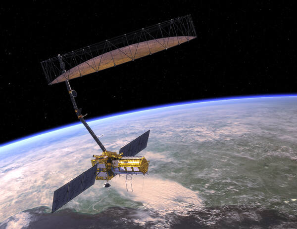
NISAR or NASA-ISRO SAR (Synthetic Aperture Radar) is a joint project of NASA ( National Aeronautics and Space Administration )and ISRO( Indian Space Research Organisation ) under an agreement signed in 2014. NISAR is a low Earth orbit (LEO) observatory a kind of satellite. This is the most advanced satellite built by any country till now for Earth observation and, the most expensive satellite with a budget of 1.5 billion US Dollars more than the valuation of an unicorn. It was originally planned to launch in 2020, but due to COVID-19, it will be launched in the first quarter of 2024 by GSLV MK II.
This satellite will map the entire globe’s surface every 12 days on ascending and descending passes, sampling Earth every 6 days for a baseline of a 3-year mission, these data will be freely available to the public.
NISAR will be put at an altitude of 747 km into an orbital inclination of 98.4 degrees in a Sun-Synchronous dawn-dusk orbit, so it will move in tandem with the Sun.

Objective of NISAR
The objective of NISAR is to study the changes in Earth in three dimensions
First is to observe the ecosystems that include vegetation, and carbon cycle, and monitor the change in estimated global carbon stock and carbon flux. This satellite will also provide maps of newly developing crop areas worldwide at an interval of every 2 weeks that affect international food security.
The second is to study the solid Earth which includes mapping the deformation of the crust and tectonic plates in millimeters that causes an earthquake, tsunamis, volcanoes, and landslides.
The third dimension is to study Earth’s cryosphere, which measures climate change’s effect on glaciers and the level of the sea at the millimeter scale.
NISAR will collect data over the Indian Coast and other regions of the Globe and monitor annual changes in the bathymetry and shoreline & erosion accretion ( build-up of sediments ).
This observatory also detects marine oil spills, and oil seepage and circulates the location for preventive measures.
Payloads of NISAR
NISAR is a 2800 kg dual-frequency L-band and S-band SAR ( Synthetic aperture radar ) satellite. This project is a collaboration between ISRO and NASA. NASA will provide the L-band SAR ( 24 cm wavelengths ) payload and other engineering payloads including Data Subsystem, a High-rate science downlink system, GPS receivers, Solid State Recorder, and radar reflector antenna.
ISRO is providing S-band SAR (10 cm wavelength) along with the Spacecraft bus (satellite body), launch vehicle GSLV, data transmission system, corresponding launch services, and on-orbit operations.
NISAR uses L-band and S-band frequencies of 1.25 GHz and 3.22 GHz, respectively. The incident angles for these frequencies are 33 degrees and 47 degrees, respectively.
The S-band is used for long-range and short-range weather observations and when mounted on NISAR it will provide excellent sub-surface penetration to study the changes in soil, whereas the L-band will study the vegetation, it can penetrate forest canopies.

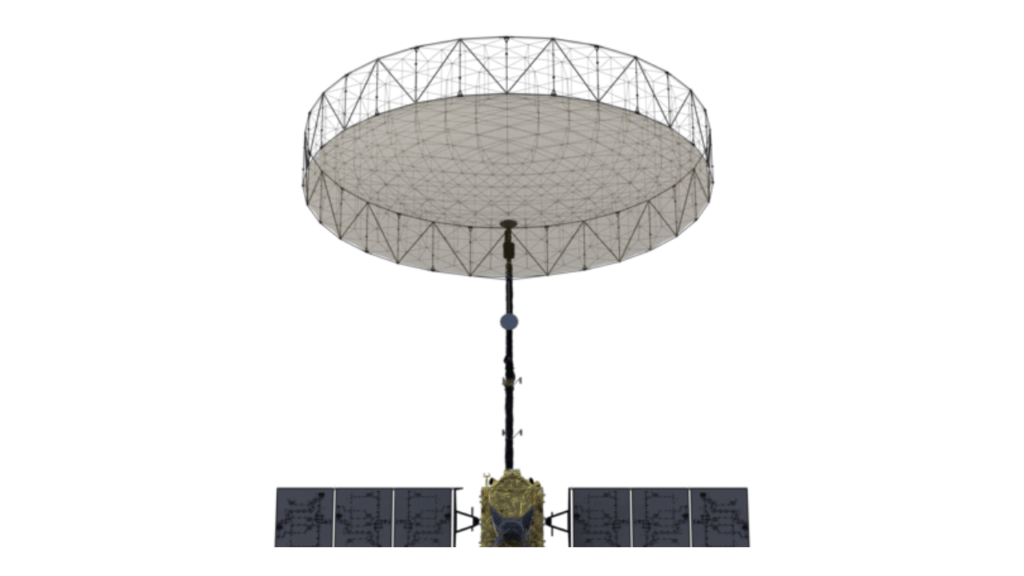
NISAR collects SSAR and LSAR radar data with a drum-shaped reflector antenna almost 40 feet (12 meters) in diameter, which is made of gold-plated wire mesh. This antenna is mounted on a deployable 30-foot (9-meter) boom.
NISAR can image a swath of 240 kilometers with an along-track resolution of 7 meters and a cross-track resolution of 2 to 8 meters.
Also read: NGLV: Next Generation Rocket for India’s Space Station by 2035
NISAR Mission Characteristics
| Orbit Altitude | 747 Km |
| Orbit inclination | 98.4 degree |
| Repeat Cycle | 12 days |
| Time of Nodal Crossing | 6 Am/ 6 Pm |
| Orbit Control | < 500 m |
| Pointing Control | < 273 arcsec |
| Pointing | Left (South) |
| L/S Duty Cycle | >50%/10% |
| Base Line Mission Duration | 3 Years |
| Consumable | 5 Years |
| Data and Product Access | Free and Open |
| Wavelength | L-band: 24 cm S-band: 9 cm |
| SAR Resolution | 3-10 m mode-dependent |
The NISAR project director from ISRO is C V Shrikant and the project manager from NASA is Phil Barela.
Mission Phase
The whole mission will be completed in three phase
1) Launch Phase
NISAR observatory launched by GSLV from Satish Dhawan Space Centre (SDSC) SHAR, Shriharikota. GSLV takes the observatory from the ground to an orbital altitude of 747 km and puts the satellite into an orbital inclination of 98.4 degrees and the satellite establishes two-way communication with the ground station.
2) Commissioning Phase
After the satellite reaches the dedicated orbit first 90 days are dedicated to commissioning or in-orbit checkout (IOC), which means preparing the satellite for operations. The commission phase is divided into 3 sub-phases which are designed to complete step by step and make the satellite ready for science operations. The first sub-phase is ISRO and NASA engineering payload checkout 2nd sub-phase is spacecraft checkout and the third sub-phase is instruments checkout.
3) Science Operation Phase
The Science operation phase will start after the completion of the commissioning phase and it will be extended for three years. During this period of 3 years, the orbit of the satellite will be maintained by regular maneuvers. First, 5 months of this phase will take place in extensive calibration and validation (CalVal) activities, and these activities repeat yearly for a 1-month duration.
Present status of NISAR
In November 2023, “NISAR” successfully completed 20 days of comprehensive testing of radio signals from antennas of two radar systems in a chamber, this test was followed by 21 days of another testing of the functions of the satellite in extreme temperature and vacuum in thermal vacuum chamber. According to JPL, there are further testing is remaining after completing all the testing it will be inserted into its launch faring. NISAR mission is expected to launch in January 2024 by ISRO from Shri Harikota, Andhra Pradesh India.
Presently two radar systems which L-band built by NASA and another S-band built by ISRO are integrated as a dual frequency radar is shipped from NASA’s Jet Propulsion Laboratory in California to ISRO’s U R Rao Satellite Centre in Bengaluru, and this dual frequency radar will combine with satellite’s body or bus and undergo for advanced testing and then ready for launch in January 2024.
In March 2021 ISRO sent its S-band radar to NASA’s JPL where NASA built its L-band radar and integrated it with S-band after two years of hard work and conducted full-fledged testing after that shipped to ISRO’s U R Rao Satellite Centre in Bengaluru by a U. S. Airforce C-17 cargo plane which reached India on March 6, 2023.
Read also Chandrayaan 4: Unlocking Lunar Mysteries Beyond Soft Landing
Read also NavIC: India’s powerful GPS-like system
What is Swath?
An area of the surface of the earth that can be imaged by the sensor of a satellite during a signal pass.
